.
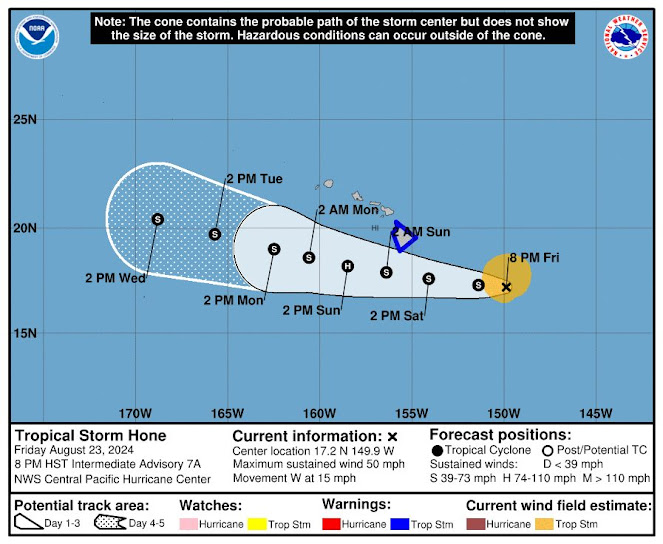
TROPICAL STORM HONE WAS located about 380 miles east-southeast of Hilo at 7:45 p.m. Friday, moving west around 16 mph. Note that the wind map shows that the earliest tropical-storm-force winds could arrive Saturday morning, The map of Hone's path shows its center going by Hawai'i Island between Saturday night and early Sunday morning.The Alert Level was raised to Warning on Friday afternoon, with the earliest possible winds coming in Saturday between 8 a.m. and 2 p.m. and the center of the storm passing by Saturday night, south of the island. Central Pacific Hurricane Center report predicts 65 mph to 75 mph winds at her center at the time Hone goes by South Point. Wind predictions for Kaʻū are 40 to 60 mph. The report at 5 p.m. Saturday also says conditions could allow strengthening and that Hone could become a hurricane.
The U.S. Air Force Reserve Hurricane Hunter aircraft sampled Hone from Friday morning into early afternoon and provided valuable data, according to the Central Pacific Hurricane Center report:
"In spite of its lack of convection, Hone maintained a well-developed low cloud field and remained surprisingly intense through the morning, well above Dvorak inputsfrom the fix agencies. Late this afternoon, deep convection is redeveloping near the center as winds aloft ease. The latest data from the Hurricane Hunters came in just before 00Z and showed maximum sustained winds holding at 45 kt and a minimum sea level pressure of 1000 mb. Given the appearance of Hone, these values will be used for the initial intensity. The initial motion is unchanged at 280/14. This general motion toward slightly north of due west will continue during the next several days as Hone is steered by a deep subtropical ridge to the north.
"However, some slowing of the forward motion is anticipated as the deep ridge to the north of Hone weakens slightly. Along this track, Hone will be passing near or just south of the state late Saturday into early Sunday, which necessitates the issuance of a Tropical Storm Warning for the Big Island of Hawai'i.
"By the middle of next week, Hone will likely become increasinglyshallow as vertical wind shear increases, allowing the low level trade wind flow to steer the system toward the west. The official forecast track is nearly identical to the previous advisory, and closely follows the tightly clustered consensus guidance near the TVCN.
"Hone has a window for intensification during the next 36 to 48 hours. Easterly winds aloft, which have inhibited outflow in all but the south and southwest quadrants, will relax tonight and Saturday as a weakness develops in the upper level ridge north of the cyclone. Sea surface temperatures will remain around 26-27C, which will be sufficient for intensification, possibly to hurricane strength, late Saturday or early Sunday.
"Late Sunday and Monday, west to northwest vertical wind shear will increase sharply, which should result in steady weakening. The intensity forecast remains on the higher side of the guidance envelope near the HCCA and slightly higher than the IVCN. Beyond 48 hours, the forecast closely follows the IVCN."
KEY MESSAGES:
1. There is the potential for excessive rainfall and flash flooding on portions of the Big Island of Hawaii starting later Saturday and continuing through Sunday as a large area of moisture associated with Hone moves over parts of the Hawaiian Islands. The heaviest rainfall will likely occur over windward and southeast facing slopes.
2. Tropical storm conditions are possible on the Big Island later Saturday into Sunday. Winds are expected to be strongest where they blow downslope from higher terrain, over headlands, and through passes.
3. Swell generated by Hone is expected to reach the Hawaiian islands Saturday night into Sunday. This swell could cause life-threatening surf and rip currents. Listen for later advisories and possible warnings from the National Weather Service
 CRITICAL CONDITIONS THAT COULD LEAD TO WILDFIRES will likely come with Tropical Storm Hone on Saturday. Winds from an offshore hurricane last year played a part in the Lahaina fire disaster.
 Hawai'i Fire Department was already contending with a wildfire between Waimea and Waikoloa on Friday evening, unrelated to the storm but subject to winds of Hone should it reach there while the fire is active.
Hawai'i County Civil Defense reports the National Weather Service issuance of a Red Flag Warning for Saturday in Kaʻū, the interior of Hawai'i Island, as well as North and South Kohala.
A Red Flag Warning means that:
Critical conditions of strong, gusty trade winds, dry fuel, low relative-humidity, and warm temperatures could produce extreme fire behavior.
Any fires that develop will likely rapidly spread and be difficult to control.
Due to these conditions, the following actions are recommended:
Avoid any activity that involves using open flames such as grilling and camp fires.
Do not park cars on dry grass after a trip.
To read comments, add your own, and like this story, see facebook.com/kaucalendar. See upcoming events, print edition and archive at kaunews.com. Support this news service with advertising at kaunews.com. 7,500 copies in the mail and on stands.
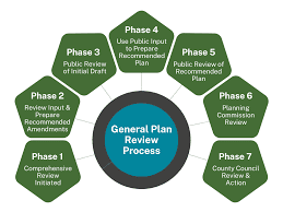
HAWAI'I COUNTY'S GENERAL PLAN 2045 IS CLOSE TO BEING FINALIZED with new updates added. They include a A Community Meeting on the new General Plan Final Draft will be held on Thursday, Sept. 19 at 5 p.m. in the Kaʻū District Gym Multi-Purpose Room: 96-1219 Kamani St, Pāhala, The General Plan is the sister plan to the Kaʻū Community Development Plan and covers the entire island.
Wednesday, Aug. 28 at West Hawaiʻi Civic Center, Building A from 2 p.m. to 4 p.m.
Thursday, Aug. 29 Arc of Hilo, 1099 Waianuenue Ave from 2 p.m. to 4 p.m.
Thursday, Sept. 5 with an Online Webinar Workshop from 5 p.m. to 7p.m. (Registration link TBD)
Thursday, Aug. 29 Arc of Hilo, 1099 Waianuenue Ave from 2 p.m. to 4 p.m.
Thursday, Sept. 5 with an Online Webinar Workshop from 5 p.m. to 7p.m. (Registration link TBD)
Additional Community Meetings will be held around the island. Public comments for this phase of developing the Hawai'i County General Plan are due Thursday, Sept. 26. giving the public 21 days after the last workshop to share comments with the Planning Director. Once this period ends, the Final Recommended Draft in its current form and all public comments will be packaged and submitted to the Windward and Leeward Planning Commissions, which will hold public hearings in November. The County Council will hold public hearings next April before finalizing the General Plan.
To read comments, add your own, and like this story, see facebook.com/kaucalendar. See upcoming events, print edition and archive at kaunews.com. Support this news service with advertising at kaunews.com. 7,500 copies in the mail and on stands.


.jpeg)

